Historical Maps
HISTORICAL MAPS FROM THE MUSEUM ARCHIVES
All maps are saved in Adobe PDF format, providing multiple browser capabilities. Download times will vary depending on your computer and internet connection.
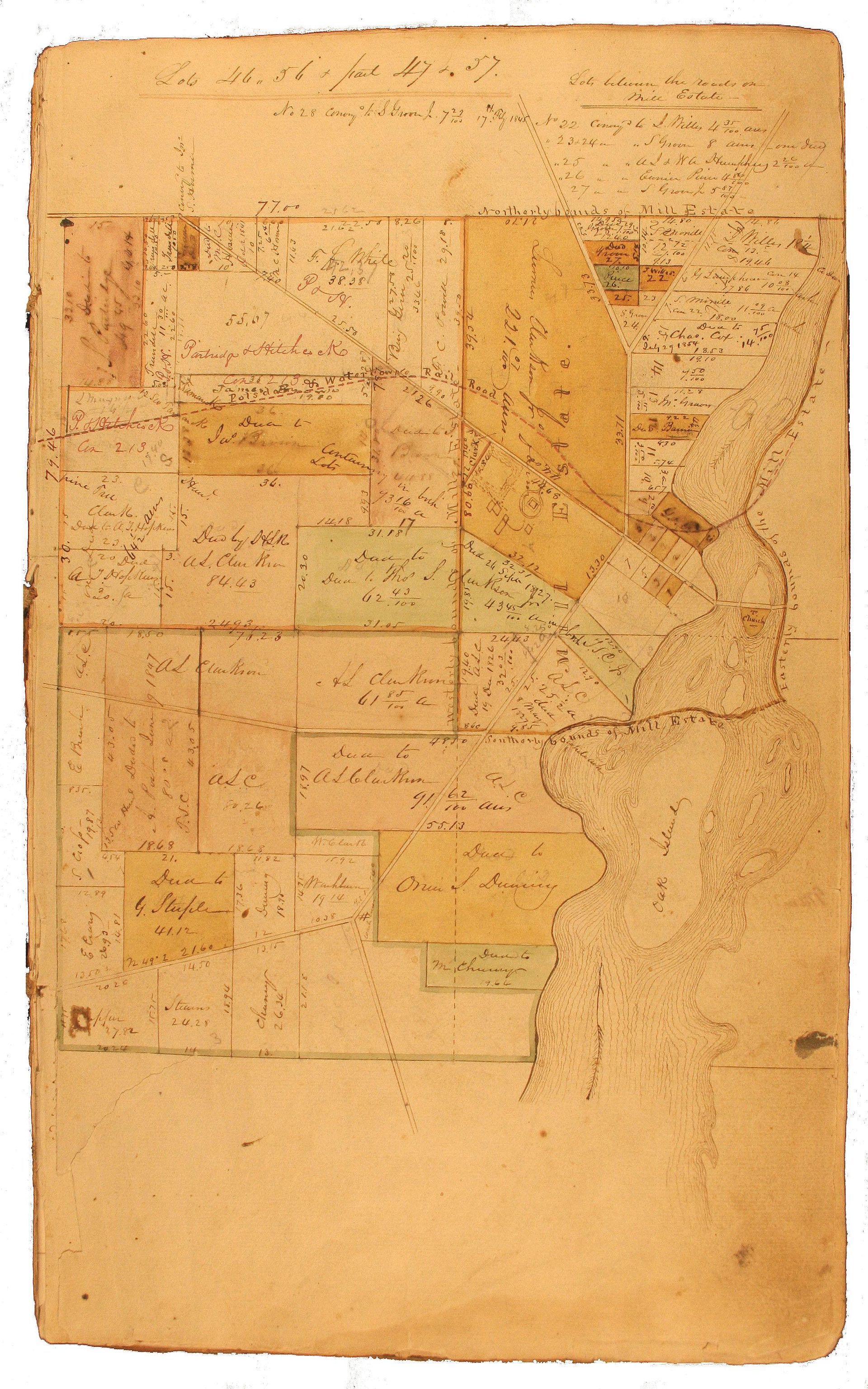
1845 T S Clarkson Maps {Lots WEST of the Racket River} {Lots EAST of the Racket River} -- These are early hand-drawn and hand-tinted maps of the Lots of the Mill Estate of Potsdam by Thomas S. Clarkson II and H. L. Knowles. The maps appear to contain annotations from 1810 through approximately 1855, to include the Potsdam & Watertown Railroad (c.1852) and the Trinity Episcopal Church (c.1835). While streets are shown, they are not named. Village Lots are numbered, property owners are identified, but it's worth noting that nothing is shown West of Market Street, along the river. Both pages are from an original 80-page book. The first page of the book contains the text: " By direction of T. S. Clarkson, 2nd, Written herein thus: This book is the property of the Proprietors of the "Mill Estate", deposited with H. L. Knowles to be by him kept for benefit and convenience of them and him and all others concerned. Also: "This book came to me among papers of H. L. Knowles and it is held by me on same considerations as above stated, Jany. 30, 1896, John Warner ".
1820 Mill Estate Map "A Map of the Mill Estate and Village of Potsdam 1820". Illustrates numbered lots, pasture and wood lots, "Improved Lands", "Conveyed Lands", "Burying Grounds", land owners, street names (including the original North & South streets), several landmarks, and the "Racket River" (spelling at the time) with islands.
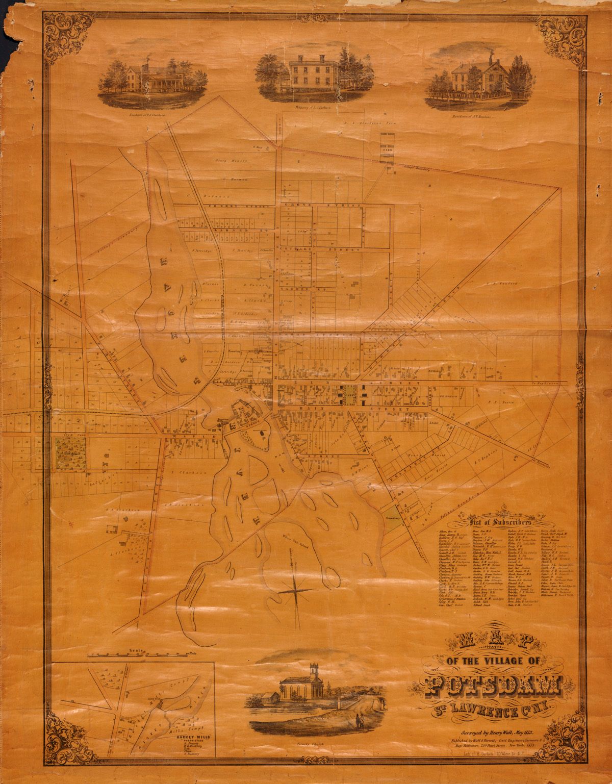
1847 Plan of the Village of Potsdam S. Raymond Still shows the original North Street (now Elm), South Street (now Main), Water & Parsonage Streets (now Bay) References include: Irvingite Chapel; Episcopal Church; Public Houses; L. Knowles Esc. - Dwelling House; S. Raymond's Store; S. Raymond's Dwelling House; Congregational conference & adjoining Building; Methodist Chapel; Town Hall; Universalist Meeting House; Academy Edifices; Congregational Meeting House; D. L. Clarkson's Mansion House; Rev. E. W. Plumb's House; Residences of the Clarkson Family; Mills, Factories & shops employing Water Power; Stores of varying kinds; Post Office.
1863 David L Clarkson Lots (Village of Potsdam) This is a copy of the Map of the Town and Village lots belonging to David L. Clarkson, October 30th, 1863. Includes lots north of Elm Street and Lawrence Avenue, both sides of LeRoy Street, and just north of Fuller Road (now the May Road).
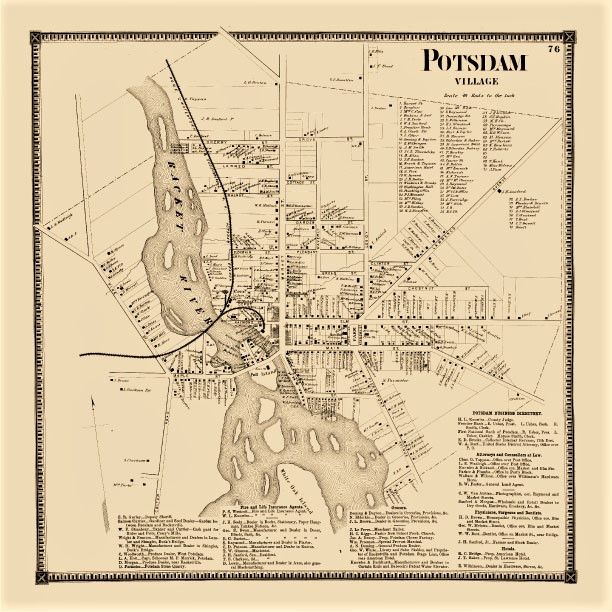
1865 Village of Potsdam (Beers page 76) Includes: Residents by name, Potsdam business directory, attorneys and counselors at law, physicians, surgeons, dentists, hotels, grocers, fire & life insurance agents, street names, the railroad, churches, schools, and the "Racket River" with islands.
1885 Panoramic Pictograph of Potsdam Published & Drawn by L. R. Burleigh, Troy N.Y. copyright secured in 1885, Beck & Pauli, Litho. Milwaukee, Wis. Includes a legend that identifies 17 landmarks and buildings.
If you'd like to view any of the maps in the Museum collection, please contact us to make an appointment.